 |
 |
| Exhibition site of a Roman “vicus” at the Saazkogel Contact: Paldau municipal office Paldau 41 A-8341 Paldau, Austria +43 (0) 3150 5110 gde@paldau.gv.at Exhibition site of a Roman “vicus” at the Saazkogel GPS co-ordinates: |
Standort des Museums: Opening hours: |
 |
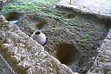 |
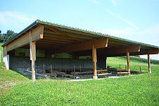
Right on the peak of the Saazkogel, there is St. Sebastian Church which mainly originates from the late Gothic period and can be seen from a far distance. First settlements on the plateau on the Eastern end of the mountain crest around the church are likely to date back to the later Hallstatt period, i.e. circa the second half of the 7th century BC. There was once an extensive Roman settlement, or “vicus”, that spread over an area of at least 9 ha. It was built in terraces, starting from the southern foot of the Saazkogel upward and is thought to have been built from wood during the Flavian-Trajan period, i.e. in the second half of the 1st century AD. This “vicus” is, together with the “vici” discovered in Gleisdorf and Kalsdorf, one of the largest Roman settlements so far in the eastern part of the Province of Styria. In 2005, a protective construction was erected within the area of the important Roman settlement and equipped with information panels. The construction covers part of the excavated stone foundations of a building as well as the structures found inside, such as fire places, cooling ditches in the form of storage containers inserted into the floor, remnants of a hose heating system and, last but not least, a well shaft holding water to this very day. For more information on the hill-top settlement and the Roman “vicus” of the Saazkogel, please click here. |

Gestaltung: Manfred Fassold, Heinz Kranzelbinder
webdesign www.fassold.com